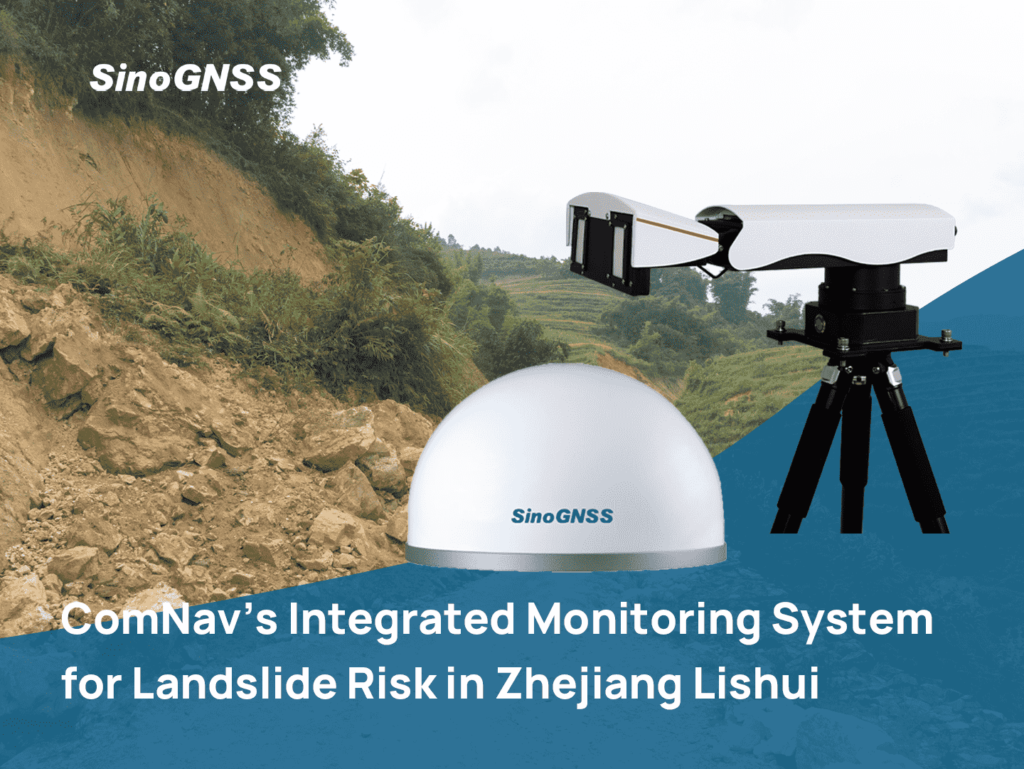

ComNav's Integrated Monitoring System for Landslide Risk in Zhejiang Lishui
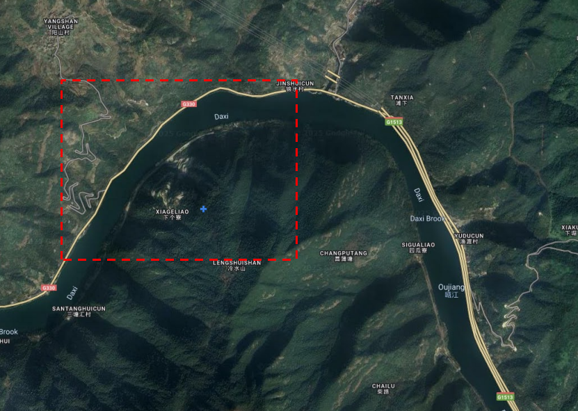
Satellite Image of the Landslide Area
Project Background
The Xia Ge Liao area in Jinshui Village has been identified as a landslide risk zone. Continuous heavy rainfall has increased the soil saturation and weight of the slope, while reducing the shear strength of the soil and rock, leading to decreased slope stability and potential hazards such as landslides and collapses. The project aims to conduct scientific assessment and monitoring of geological disaster risks in the area to ensure the safety of local residents and property.
Project Challenge
Monitoring landslide risk in areas with unstable soil and frequent heavy rainfall.
Ensuring continuous and reliable monitoring of multiple disaster points across complex terrain.
Collecting real-time data and transmitting early warning information under harsh environmental conditions.
Customer Information
Customer: China Geological Environment Monitoring Institute (CGEM)
Official Website: www.cgem.org.cn
Project Timeline
November 2024 (field trial completed)
Project Location
Jinshui Village, Lishui City, Zhejiang Province, China
Equipment Used
GNSS Receivers (A300, A500)
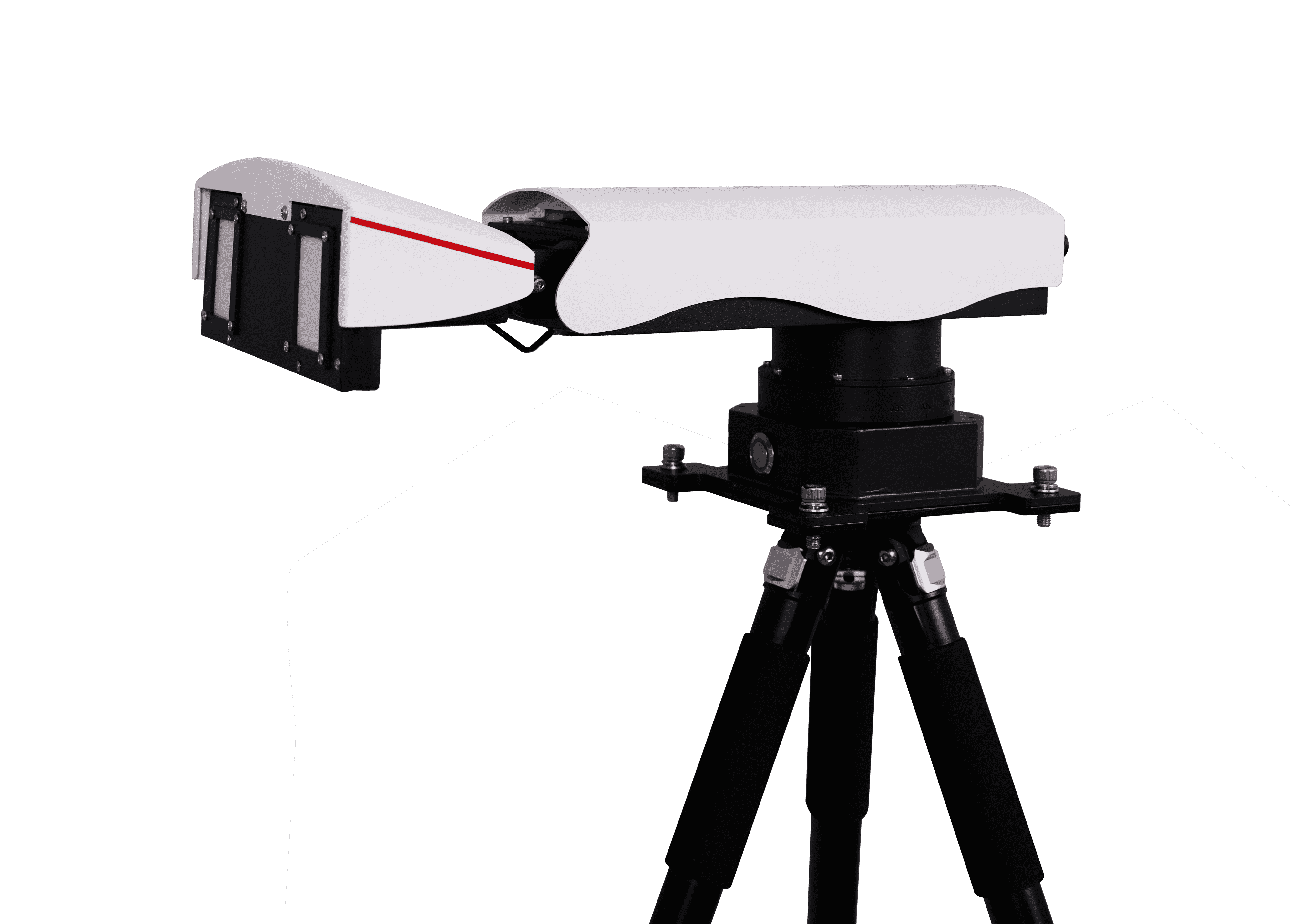
MS-SAR1000 Slope Radar
Crack Meter
Inclinometer
Tipping Bucket Rain Gauges
Soil Moisture Monitoring Instruments
Intelligent Sound and Light Alarm Devices
System Design and Monitoring Platform
The landslide monitoring system in Xia Ge Liao, Jinshui Village, Lishui City, consists of three main components: monitoring point sensor systems, a control center, and an automated monitoring and early warning platform. Together, they form a complete loop from data collection and processing to alert issuance, ensuring real-time, all-weather monitoring of landslide risks. The system adopts a multi-source fusion monitoring solution combining GNSS receivers, slope radar, and multiple environmental sensors, enabling high-precision, continuous data acquisition.
Monitoring Point Sensor System
The monitoring point sensor system in Xia Ge Liao, Jinshui Village, Lishui City, consists of multiple high-precision sensors that provide all-weather monitoring of slope stability. The A300 and A500 GNSS receivers, combined with the MS-SAR1000 slope radar and crackmeters, can obtain real-time Sky-Earth-Ground 3D monitoring data from the monitoring points, allowing analysis of dynamic slope displacement and long-term deformation trends.
✔ Tipping bucket rain gauges record rainfall in real time, providing hydrological data for landslide risk assessment. These gauges monitor rainfall intensity and distribution, allowing for better prediction of potential slope failures due to water infiltration.
✔ Soil moisture monitoring instruments measure water content and temperature at various soil depths. This real-time data is crucial for assessing slope stability, as it helps understand how moisture variations affect soil behavior at different depths, enabling more accurate risk evaluations.
✔ Tiltmeters track slope inclination in real time, detecting any abnormal deformation. These devices are essential for identifying early signs of instability, offering valuable data for assessing the risk of a landslide.
✔ Sound and light alarm devices are linked with the sensors to deliver immediate on-site alerts. In case of abnormal readings, these alarms ensure that personnel receive prompt notifications, enhancing safety measures in the field.
Through multi-source data fusion, the system enables automated real-time monitoring of critical parameters such as slope displacement, soil moisture, and rainfall. This integration provides a comprehensive and solid basis for ongoing risk assessment and decision-making in landslide management.
Automated Monitoring and Early Warning Platform
The automated monitoring and early warning platform is the core of the system, providing information management, data visualization, and intelligent analysis. The platform receives data from GNSS receivers, slope radar, and other sensors in real time, storing, analyzing, and processing it online. Monitoring data is automatically compared against preset thresholds to determine alert levels. When thresholds are exceeded, the platform triggers automated alerts, including sound and light alarms and remote notifications to relevant personnel. Users can access real-time maps, project status, and historical data remotely, supporting multi-user collaborative management. The platform also generates monitoring reports, summarizing the operational status of all monitoring points and alert records, supporting disaster prevention and risk management decision-making.
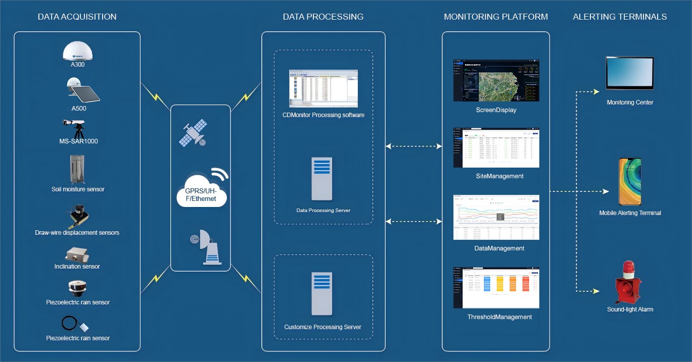
Data Transmission and Communication
The system uses multiple wireless communication methods, including 4G, NB-IoT, and LoRa, to transmit monitoring data to the control center server in real time, ensuring continuous and reliable information flow. This stable data transmission enables all-weather monitoring and rapid response under unattended conditions, making landslide risk management more efficient and scientific.
Monitoring Network
The monitoring network is arranged around landslide-prone areas, with key monitoring points including GNSS base stations and environmental sensors. These points track slope displacement and stability in real time, transmitting data to a central server for centralized management and unified analysis.
Deformation Data
Deformation data collected by GNSS receivers, slope radar, and other sensors is displayed in real time on the monitoring platform, showing changes in slope stability. The system can automatically generate alerts when thresholds are exceeded, allowing relevant personnel to take quick intervention measures and reduce potential risks.
Cloud platform display
COMNAV SmartMonitor Cloud Platform can view the real-time distribution of map projects and real-time warning information, supporting project manage, device management, data management, as well as alert threshold management & report export.
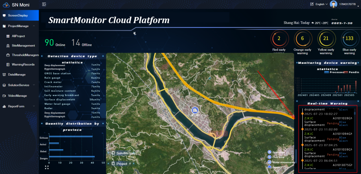
It allows users to access comprehensive project information, enabling them to select a specific project and view its detailed data. It also provides precise location details for each site within the project, including latitude, longitude, elevation, online status, and last update time. Users can analyze data and view line graphs categorized by device type and time, with the option to toggle between different monitoring categories to view various types of data and images. The system supports the display of single, multiple, or all data types, and offers the ability to export both monitoring data and images. Furthermore, it facilitates the management of alert thresholds, the assignment of responsible personnel, the viewing of project overviews, and the export of detailed reports.
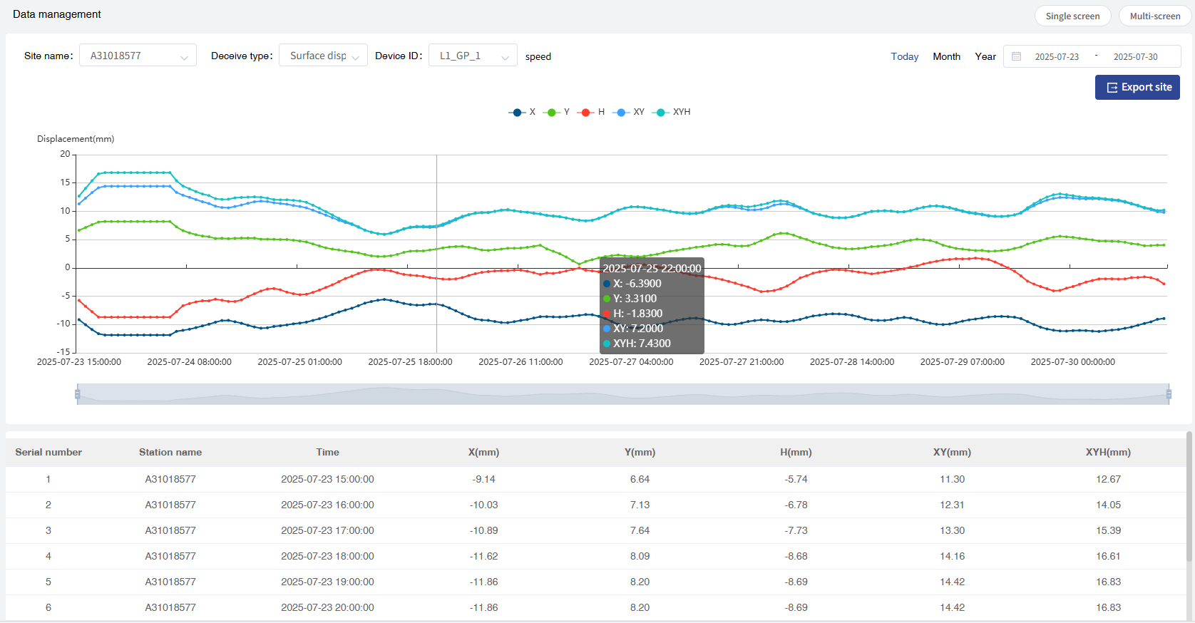
Data of Displacement Sensor
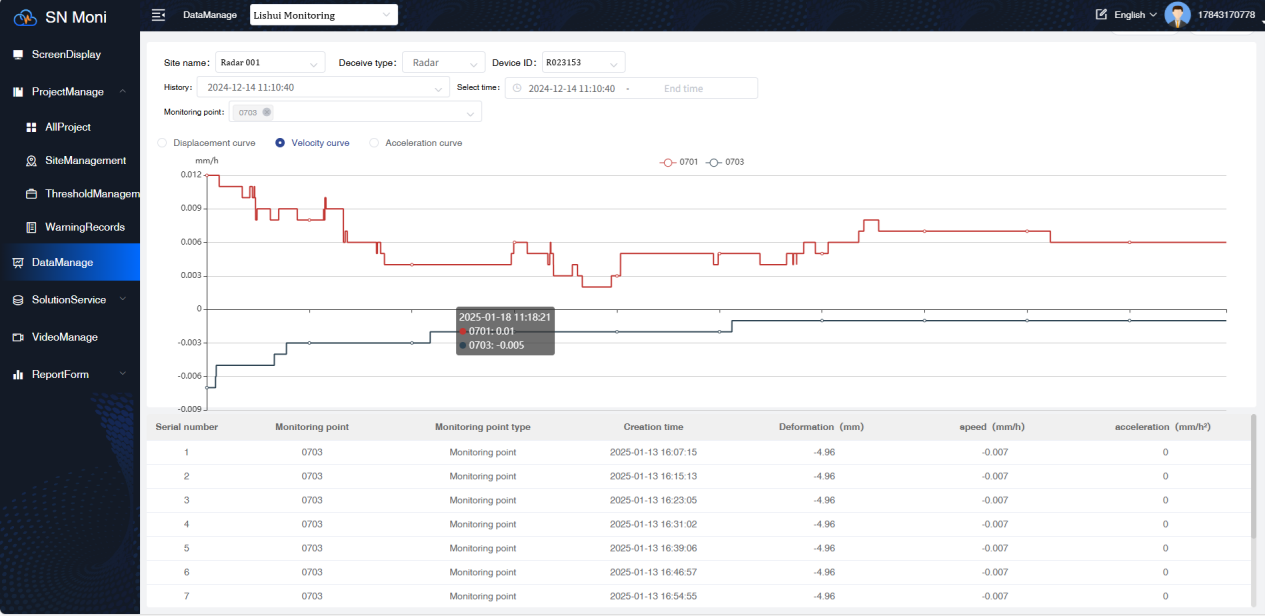
Data of Monitoring Radar
Project Summary
The Lishui Landslide Monitoring Project, implemented by ComNav Technology, provides a reliable real-time monitoring and early warning solution for landslide risks. By combining GNSS receivers, slope radar, and various environmental sensors, the system enhances the ability to predict and prevent landslide hazards, ensuring the safety of local communities and infrastructure. The system supports all-weather, unmanned operation, maintaining stability under extreme weather conditions such as typhoons, heavy rain, and dense fog, providing strong support for rapid response and real-time slope monitoring.
Beyond Lishui, ComNav has also contributed to diverse monitoring projects across various regions in China, including Chongqing, Wuhan, and Shandong. These projects, with their unique environmental and geological conditions, demonstrate the versatility of ComNav’s technology in addressing different monitoring needs. Our GNSS receivers, slope radar, and environmental sensors continue to play a crucial role in supporting the safety and resilience of local communities.
If you have any monitoring needs or inquiries, feel free to reach out to us anytime. We’re always ready to assist!
About ComNav Technology
ComNav Technology develops and manufactures GNSS OEM boards and receivers for high precision positioning demanded applications. Its technology already been used in a wide range of applications such as surveying, construction, machine control, agriculture, intelligent transportation, precise timing, deformation monitoring, unmanned system. With a team dedicated for the GNSS technology, ComNav Technology is trying its best to supply reliable and competitive products to worldwide customers. ComNav Technology has been listed on the Shanghai Stock Exchange (Science and Technology Board), securities :ComNav Technology (Compass Navigation), Stock code: 688592.
About SinoGNSS®
SinoGNSS® is the official trademark of ComNav Technology Ltd., registered in People's Republic of China, EU, USA and Canada. All other trademarks are the property of their respective owners.
About ComNavTech®
ComNavTech® is the official trademark of ComNav Technology Ltd., registered in People's Republic of China, EU, USA and Canada. All other trademarks are the property of their respective owners.