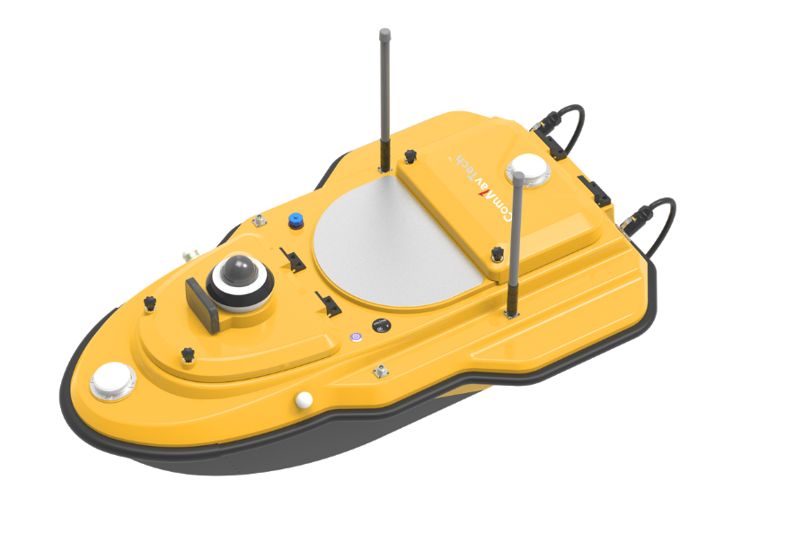
SV300 Unmanned Surface Vessel
Introduction
Product Parameter
Download
Recommend Product
Get Information
Introduction
SV300 Unmanned Survey Vessel adopts a highly integrated main control design, featuring a built-in high-precision GNSS positioning system, depth sounder, and vessel control software, streamlining your surveying operations. Equipped with intelligent vessel control system, it offers a high level of automation, strong disturbance resistance, and excellent hull expandability. It can be fitted with echo sounders, side-scan sonar, water quality sensors, and other instruments, enabling efficient and accurate automatic collection, processing, and analysis of underwater terrain, multi-parameter water quality, and specific target information.


  • Integrate GNSS Antenna
  • Obstacle Avoidance Radar System
  • Quick Installation
  • IP67 Dustproof & Waterproof
  • High-speed Propeller with Long Life
  • Auto Measurement of Cross Section & Line
  • Vessel Battery Status
  • Integrated Master Control Design
01
Streamlined Design
SV300 features streamlined design that makes transportation simple and efficient. With no assembly required, it is ready to operate straight out of the box, ensuring fast and hassle-free deployment in the field.
02
Uninterrupted Positioning with GNSS+IMU
The SV300 is outfitted with ComNavTech's dual-antenna GNSS module, featuring full-constellation multi-frequency tracking.This enables precise positioning and navigation.With an integrated lMU, it ensures continuous availability of position data, even during temporary GNSS signal loss.
03
Millimeter-wave Radar Automatic Obstacle Avoidance
With its advanced radar technology, the obstacle avoidance radar system ensures safe operations by detecting obstacles and providing timely alerts to users, allowing for quick and effective navigation even in low-visibility conditions.
04
360° Night Camera
With 360° real-time camera technology, you can immerse yourself in the environment,enhancing navigation safety.
05
Automotive-grade Dual Lithium Battery Pack
Equipped with a balanced, automotive-grade dual lithium battery system, SV300 delivers reliable, long-lasting power. Its robust endurance ensures stable performance, making it perfectly suited for extended field operations.
06
Versatile Equipment Compatibility
SV300 supports an expandable payload platform that allows integration of various sensors and instruments.
Product Parameter
Vessel Specifications
Power
Communication
Positioning
Remote Controller
Depth Measurement
Vessel Specifications
Hull Dimension980 x 520 x 254mm
Material

High-Molecular Carbon Fiber, 

Kevlar Fabric

Hull ShapeFully Curved M-Shaped Monohull
Water Proof & Dust ProofIP67
WeightEmpty 7 kg, Loaded 30 kg (Including Base Station, Controller, and Battery)
Maximum Payload35kg
Weather Rating

3-class Wind

2-class Wave

Draft8.5cm
Safety Protection Design

Automatic Return in Shallow Water; 

360° Panoramic Camera,

Automatic Obstacle Avoidance, 

Forward ±120° Field of View; 

Detection Range 0.1–20m (Optional 40m Module Available), 

Full-Body Bumper Strip, 

Reinforced Hull Structure, 

Dual Redundant Anti-Collision Design

Equipable DevicesOptical Cameras, Lidar, Echo Sounder, Water Quality Sensors, Meteorological Sensors, Multi-Parameter Probes, Automatic Water Sampler, Side-Scan Sonar, Etc. SDK Open for Secondary Development
Power
MotorBrushless DC Motor
Propeller

Brushless Direct Drive, 

Foldable Propeller

Rated Power900W
Rated Speed5300 RPM
Motor Protection

Semi-Submersible Design;

Waterproof Shaft Seal with Circulating Cooling; 

Anti-Entanglement Design; 

Debris-Resistant

Battery33.6V 25Ah × 2 High-Energy-Density Lithium Batteries (Supports Rapid Battery Replacement Without Power Shutdown)
Endurance (Time)One Battery Pack: 3h@2m/s, 7h@ 1.5m/s
Endurance (Distance)Economical Cruise Range 38 km
Navigation Speed7 m/s; Supports Safe Navigation at 4 m/s in Turbulent Waters
Communication
Basic CommunicationRadio (Optional) & Network & CORS
Video Communication4G & 2.4G
Data Communication4G & 2.4G & Radio (Optional)
SIM Card Slot

Nano Card Slot

Interfaces2×RJ45 Ethernet Ports, 2×RS232 Serial Ports, 2×RS485 Serial Ports
Control ModeManual & Automatic
Positioning
Signal TrackingGPS: L1C/A, L2C, L2P
BDS: B1I, B2I, B3I
GLONASS: G1,G2
Galileo: E1, E5b
QZSS: L1C/A, L2C
SBAS: L1C/A
Cold Start

<30s

Initialization Time<5s (D<10km)
Single Point Position (RMS)≤ 1.5m (Horizontal)
≤ 2.5m (Vertical)
DGNSS Positioning Accuracy40cm+1ppm (Horizontal)
80cm+1ppm (Vertical)
RTK Positioning Accuracy

±8mm+1ppm (Horizontal) 

±15mm+1ppm (Vertical)

CORS Correction SourceSupported CORS Network
Radio DifferentialSupports TT450 protocol / Transparent Transmission Protocol (TTP)
Heading Accuracy±0.1° (1m at 1m Baseline)
Roll / Pitch Accuracy6°/h, 20s Rotation Time, Supports Dynamic Self-guided Positioning
IMU Update Rate200 Hz
Remote Controller
Dimensions277 × 138 × 96 mm
Display

Industrial-Grade Display, Sunlight-Readable, 1920 × 1200

Memory

4 GB RAM, 64 GB ROM

Frequency Band2.400–2.483 GHz
Communication Range

Effective Distance Up to 3 Km,

Supports 4G Remote Control

Battery Capacity20,000 mAh
Operating Time8 h
Charging

18W Fast Charging,

Standard Type-C Port

InterfacesPPM, RJ45, USB, Type-C, SIM Card Slot, TF Card Slot
Control Functions

One-Button Power On/Off,

Auto/Manual Sailing, 

Cruise/Patrol/Navigation, 

Route Planning, Security Monitoring, 

Vessel/Remote Control Information Synchronization, 

Video Display & Recording, 

Main Video Window Swap, 

One-Click Video Screenshot

SystemLinux
Depth Measurement
Frequency200KHz
Waveform

Measuring Range

0.15–200m (Adjusted for Range)

Resolution8mm
Stability

±2cm (CEP.95@10m)

Measurement Rate±1cm+0.1% D (D=Water Depth)
Power Supply9V~28V
Speed

0m/s–1700m/s

Power Consumption5–10W
Download
  • SV300 Unmanned Surface Vessel.pdf(8.52MB)
    2025-11-19
Recommend Product
Get Information

Product Name

Name *

Phone *

E-mail *

Company

Country *

    Subscribe to Our Newsletter

    • No
    • Yes

    Inquiry Content *

    Captcha*