
U70 Radio Firmware v2.1.2 Adds Multi-Protocol Support Including Transparent Transmission
The SinoGNSS U70 LoRa radio now extends its compatibility with the release of firmware v2.1.2, adding support for multiple communication protocols: LoRa/Transparent/South/Mac/TT450S.
In 2020, ComNav officially released the U70 data transmission module, which adopted the LoRa protocol for the first time to achieve ultra-low power consumption and long-distance communication. With its outstanding anti-interference capability and industrial-grade stability, the module quickly became the preferred communication solution for high-precision GNSS devices. However, the limitation of supporting only a single protocol posed a clear ecological constraint: it could not interoperate with most mainstream radio modules on the market.
Today, we are proud to announce that after four years of dedicated technical breakthroughs, this issue has been fully resolved. Without changing any hardware, a simple firmware upgrade now enables seamless switching between LoRa and protocols such as Transparent.
The following table provides a clear and intuitive comparison of the protocol support, power consumption, working range, and other parameters of the U50, old U70, and new U70 data transmission modules.
U50 | U70 old version | U70 new version | |
Size | 30mm×40mm×3mm | 30mm×30mm×3mm | 30mm×30mm×3mm |
Supported Protocols | Transparent/South/Mac/TT450S | LoRa | LoRa/Transparent/South/Mac/TT450S |
Working Distance | 1-5km | 5-12km | 5-12km |
TX Power Consumption | 6.6W | 2.7W-5.4W | 2.7W-5.4W |
RX Power Consumption | 0.6W | 0.15W-0.16W | 0.15W-0.16W |
Below are some commonly used configuration commands for the new version of the radio.
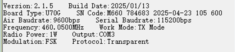
1. Read Radio Information
Command: $$01log radioinfo
Example Output:
2. Set TX or RX mode
Format: $$01RX/TX
Description: This command is used to set the radio to receive/transmit mode
Parameters: RX for receive, TX for transmit
Example: $$01RX
3. Set Modulation Type
Format: $$01set lora/fsk
Description: This command is used to set the radio's modulation mode.
Parameters:
1- lora: Configures the radio to use the LoRa protocol.
2- fsk: Configures the radio to use FSK modulation. In this case, the protocol type must also be specified to determine which protocol to use (default protocol: Transparent).
Example: $$01set lora
4. Set Communication Protocol in FSK Mode
Format: $$01protocol=1/2/3/4
Description: This command configures the communication protocol in FSK mode.
Parameters:
1 - MAC protocol
2 - TT450 protocol
3 - Transparent protocol (default)
4 - SOUTH protocol
Example: $$01protocol=1
5. Set Radio Frequency
Format: $$01fre=415.0500
Description: Set the radio operating frequency to 415.0500 (Note: The U70 supports a frequency range of 410-470MHz. The command requires 3 digits before the decimal point and 4 digits after).
6. Set Air Baud Rate
Format: $$01set airbt <baudrate>
Description: This command is used to set the air baud rate. If the input parameter is 11000, 18000, 31000, 52000, or 115200, it will be recognized as LoRa; other baud rates will be recognized as FSK. After this command is entered, the radio will automatically switch to the corresponding modulation type once the air baud rate is configured.
Parameters: Valid baud rate values are: 11000, 18000, 31000, 52000, 9600, 19200, 115200.
Example: $$01set airbt 11000
7. Set Radio Transmit Power
Format: $$01set power <H/M/L>
Description: This command is used to set the transmit power of the radio during operation.
Parameters: H stands for 2W; M stands for 1W; L stands for 0.5W.
Example: $$01set power h
If you encounter any issues while using the U70, please don’t hesitate to contact us.
About ComNav Technology
ComNav Technology develops and manufactures GNSS OEM boards and receivers for high precision positioning demanded applications. Its technology already been used in a wide range of applications such as surveying, construction, machine control, agriculture, intelligent transportation, precise timing, deformation monitoring, unmanned system. With a team dedicated for the GNSS technology, ComNav Technology is trying its best to supply reliable and competitive products to worldwide customers. ComNav Technology has been listed on the Shanghai Stock Exchange (Science and Technology Board), securities :ComNav Technology (Compass Navigation), Stock code: 688592.
About SinoGNSS®
SinoGNSS® is the official trademark of ComNav Technology Ltd., registered in People's Republic of China, EU, USA and Canada. All other trademarks are the property of their respective owners.
About ComNavTech®
ComNavTech® is the official trademark of ComNav Technology Ltd., registered in People's Republic of China, EU, USA and Canada. All other trademarks are the property of their respective owners.